Maps are a great way to make some web sites about historical travels easier to understand. I have been enhancing some of parts of this blog, some of which is about family history, with maps and describe how I do it here, so you, if you wish, you can do the same. All the tools I use are Free, both in the sense that you do not have to pay for them, but more importantly they are developed by individuals or communities who believe that open sharing of information and helping others makes the world a better place.
I have maps created this way on (at least) the following pages
- The Bell of the Kishon – a sailing ship travelling between Britain and Australia in the 1800’s
- Whatever happened to the Williams sisters – the tale of three girls orphaned before their tenth birthdays.
- Margaret Box, nursing in Salonica and Serbia – a civilian nurse going to help in Serbia in 1918..
- Margaret’s journey from Skopje to Thessalonki – by train mostly, except where the fighting had destroyed bridge.
WordPress
WordPress is a very popular choice for building web sites. You can host it on your own server, as I do, or try it by creating a basic – free – account at https://wordpress.com/ although to install plugins you will need to upgrade to a paid (Business) account, which costs (in October 2020) £20 per month. As I have my own server I have not investigated other options, but I know there are many places offering WordPress Hosting, but you need one which allows you to install plugins.
Plugins are the way a WordPress site can be extended beyond the standard functions. A huge range are available if you need something the basic version does not provide.
OpenStreetMap
With more that two million contributors, OpenStreetMap is a not just a map of the world, but a resource of Geographic information used by researchers and charities (particularly in relation to mapping parts of the world which may not deliver a commercial return, but where maps are still needed such as the Humanitarian OpenStreetMap Project).
The WordPress OpenStreetMap Plugin
Bringing two good things together, the WordPress OpenStreetMap plugin allows you add OpenSteetMap maps to your WordPress site. It is primarily aimed at people who want to show where they have been in recent or planned modern journeys, but can be used for showing historical maps. It displays a map with markers you can set when configuring the plugin, or for more complex use, a KML file.
A KML file is a way to describe, in a computer file, a group of Geographical features, such as places, or routes to pass them from one program to another. I generate these KML files with a program called Viking, described below.
I then need to copy the kml file to my WordPress server – for security reasons WordPress prevents unknown file types from being uploaded through its normal media upload, and although the plugin adds kml to the valid file types, and I have added it to the valid types in my WordPress settings the uploads are still refused (I will update this if I find a solution, and it may be particular to my setup).
Viking
Viking is really intended to be a GPS editor, but can be used to create the KML files for historic maps.
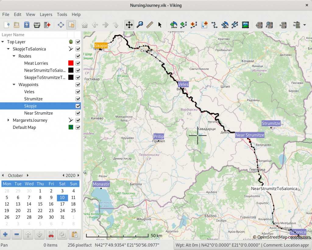
To generate the file I use with the OpenStreetMap Plugin I right click a Layer (journey) and select Export As…/Export as KML
As I said above this software is really aimed at people working with GPS in the present and the version I am using just now needs, for example, scrolling the date of a ‘way point’ back through many years to set it, but the developers are helpful and responsive, as you can see from the responses to my suggestions about updating dates and places.
If several people are working on the same set of journeys then they could collaborate by exchanging the .vik files used to record the places, dates etc, as the information held can be quite rich with images etc.
GpsPrune
GpsPrune is another GPS editor, which can also be used to create waymarks (points) and save them as a KML file.